• Home
  • About
  • People
  • Research
    • Ecohydrology
    • Geomorphology
    • Hydroinformatics
  • Publications
  • News
  • Teaching
  • Photos
  • Contact
  • Home
  • About
  • People
  • Research
    • Ecohydrology
    • Geomorphology
    • Hydroinformatics
  • Publications
  • News
  • Teaching
  • Photos
  • Contact

Geomorphology

We study geomorphology from time-scales of mountain evolution to flood response

Integrated modeling of hydro-geomorphic hazards: floods, landslides, and sediment

​​NSF PREEVENTS grant

The overarching objective of this project is to improve our ability to forecast flood and landslide risks by targeting the challenges associated with incorporating sediment sources and fluxes into flood prediction. Below are some sample publications from this project:
​
Picture
Picture
Picture
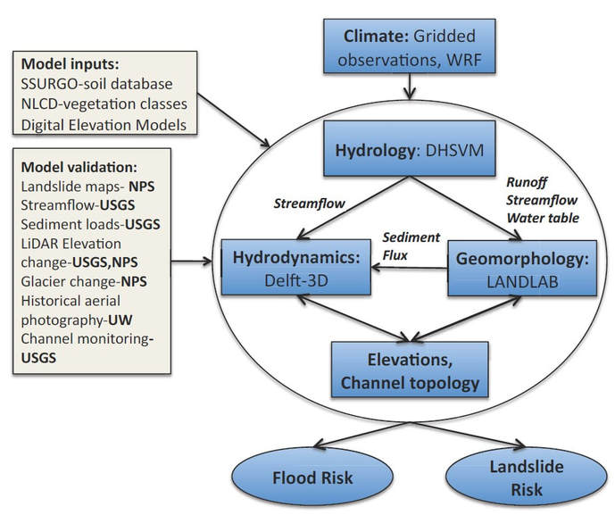
Modeling framework for PREEVENTs research
Overview
This research addresses an important gap in flood modeling: While the ability to model the hydrologic and hydraulic aspects of floods is mature, flood models do not sufficiently resolve sediment dynamics in river networks and related consequences for channel conveyance. Especially in tectonically active regions, changes in channel capacity due to geomorphic processes may sometimes be as or more important than the frequency of high discharge events in determining flood risks. The overarching objective of this project is to improve our ability to forecast flood and landslide risks by targeting the challenges associated with incorporating sediment sources and fluxes into flood prediction.

Co-Investigators and collaborators: Alex Horner-Devine, Christina Bandaragoda, Nirnimesh Kumar, Jessica Lundquist, David Shean, Brian Collins, David Montgomery, Guillaume Mauger from UW, and Kris Jaeger, Scott Anderson, Eric Grossman, Erin Whorton (USGS), Jon Riedel, NPS.
 
​
Methods
To accomplish this objectives, we are developing a holistic, process-based, mountain to coastline (M2C) modeling framework which will integrate hydrology, geomorphology and hydrodynamics models in a modular fashion across a range of process domains extending from hillslopes where sediment is primarily sourced to depositional environments where flood risk is impacted [Collins and Montgomery, 2011].
 
Upland and channel geomorphic processes are modeled using Landlab, a recently developed toolkit for modeling geomorphic processes. Landlab is also incorporated into an integrated flood modeling framework that includes hydrology (DHSVM) and fluvial geomorphology and flooding (Delft3D) models for the Skagit River and Mt Rainier drainage in WA.  


Anticipated results
This framework will be extensively validated and used, together with existing observations and remote sensing data, to address the following questions:
 
(1) What are the dominant geomorphic processes that lead to sediment supply and channel change in our study systems, and how they can be represented in the proposed model?
(2) How do geomorphic processes, including landsliding, debris flows and channel storage, affect flood risk?
(3) How will flood risk change in the future, given expected changes in geomorphic processes?


Road prescription-scale effectiveness monitoring project

High-traffic, near-stream (HTNS) unpaved forest roads associated with timber production are some of the largest sources of excess, human-caused fine sediment in nearby streams. This fine-grained sediment generated by and transported from HTNS forest roads can adversely affect water quality and aquatic resources in nearby watersheds. 

The Road Prescription-Scale Effectiveness Monitoring Project (RPSEMP) aims to study the erosion of unpaved forest roads in western Washington and the best ways to mitigate such erosion. This project is funded by the Cooperative Monitoring, Evaluation, and Research (CMER) Committee within the Washington Department of Natural Resources (WADNR) Adaptive Management Program. ​
Picture
Picture
The project design includes the collection of extensive field data in western Washington, as well as the development of a process-based model. RPSEMP is a collaborative effort among members of WADNR, Rayonier, the United States Forest Service (USFS), and the Watershed Dynamics Research Group at the University of Washington. The project consists of three main parts: the major experiment; the parameterization experiments; and the modeling. 

The major experiment is designed to measure annual sediment load and quantify how forest road best management practices (BMP) that are put in place affect that sediment load. Sediment and flow data are being collected at each of the 78 field sites (80-meter segments of road) installed in western Washington. At a few subsets of these sites, traffic and rainfall data are also being collected. The parameterization experiments are designed to help answer six critical questions posed in our study design that are not necessarily answerable by the major experiment alone. The modeling component of this project is designed to develop a process-based model of forest road erosion that incorporates the effects of traffic and BMP. The model is being developed using Landlab, a Python-based Earth surface processes modeling toolkit.

The Watershed Dynamics Research Group has been extensively involved in the development and implementation of multiple parameterization experiments, specifically those related to the hydraulics of roadside ditch lines and the micro-topographical changes of the road surface over time. The group's main involvement, though, is in the model development.

Picture
Picture
Picture

Landslides in the North Cascade Mountains
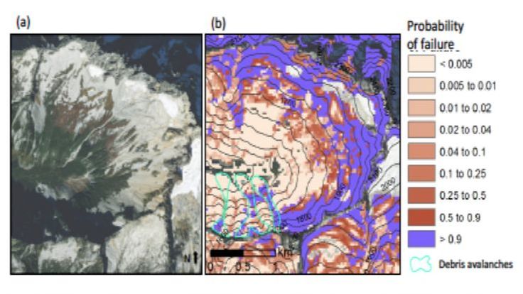
Using a geomorphic approach (landscape topographic dynamics), we are developing new ways to predict probabilistic landslide hazard at regional scales using Landlab. The model applications are reproducible on HydroShare (instructions in the link). Our Monte Carlo approach connect uncertainties of the effects of vegetation, soils, and climatology on hillslope stability based on both the infinte slope stability model and empirical data. The products of these models include probabilistic landslide hazard maps that explicitly address uncertainty in site specific information. These maps and our approach can facilitate quantifiable risk assessments that can inform design and decision making in engineering, planning, emergency preparation, and resource management.  We demonstrate our approach in the North Cascade mountains of Washington, where steep terrain, active tectonics, glacier dynamics, and high precipitation contribute to relatively frequent landslides. This research was funded by NSF, CBET-1336725. Probability of landslide initiation is illustrated with a figure on the left from Strauch et al. (2018): (a) high-resolution (0.3 m) imagery of a NOCA mountain compared to (b) P(F) simulated by modeled soil depth with mapped debris avalanches. Imagery from World Imagery, Esri Inc., created using ArcGIS® software by Esri.
Picture

​Sediment Supply and Transport Behind the Historic Elwha River Dams
Existing sediment supply and transport models used for reservoir operations are based on simplifying assumptions that poorly represent extremely complex conditions in mountainous river and reservoir systems.  The goal of our research is to develop a novel, continuous modeling approach to sediment supply and transport using state-of-the-art tools that allow for process-based representations of relevant and dominant geomorphic phenomenon driven by hydrology. Historic Elwha River landscape sediment supply and transport will be simulated using a new modeling framework for earth surface dynamics called Landlab driven by hydrology from the Distributed Hydrology-Soils-Vegetation Model (DHSVM). We aim for the model to reconstruct the accumulation of sediment behind the historic Elwha River dams of the Olympic Peninsula, Washington. When the Elwha River dams were removed in 2011 it marked the largest dam removal in history, and the dams had approximately 21 million cubic meters of sediment accumulated behind them. Retrospective analysis of this river and dam system allows the ability to test our modeling approach. We hope that this modeling appraoh can be used for sustainable planning and management of reservoir sedimentation in consideration of social and ecological factors along with changing climatic and environmental conditions. This research is sponsored by the Hydro Research Foundation, Northwest Climate Science Center, and NSF Graduate Research Fellowship Program.
Powered by Create your own unique website with customizable templates.